No platform monitors freshwater ecology end to end. Not the bird-recording charities. Not the invertebrate networks. Not the water quality reports. Not the BNG tools.
Each of them does one thing. Hydroscape does all of them, against one dataset, in one platform, accessible to anyone with a phone — and the cormorant funnel is end-to-end free for fisheries.
That is the argument of this piece. The rest of it is the case.
We set out as experienced fishery managers to solve a problem on our own waters. What we found was that you cannot solve one without solving all of them, and you cannot solve them on one water without solving them everywhere. Predation evidence is meaningless without the biodiversity record around it. A biodiversity record is partial without the water quality picture. Water quality is local until it is national. Specialisation, however excellent within its lane, makes the problem worse the more it specialises.
The list of what one platform should cover is long. The list of what no other platform covers is longer. The list of what Hydroscape now does is the same as the first list.
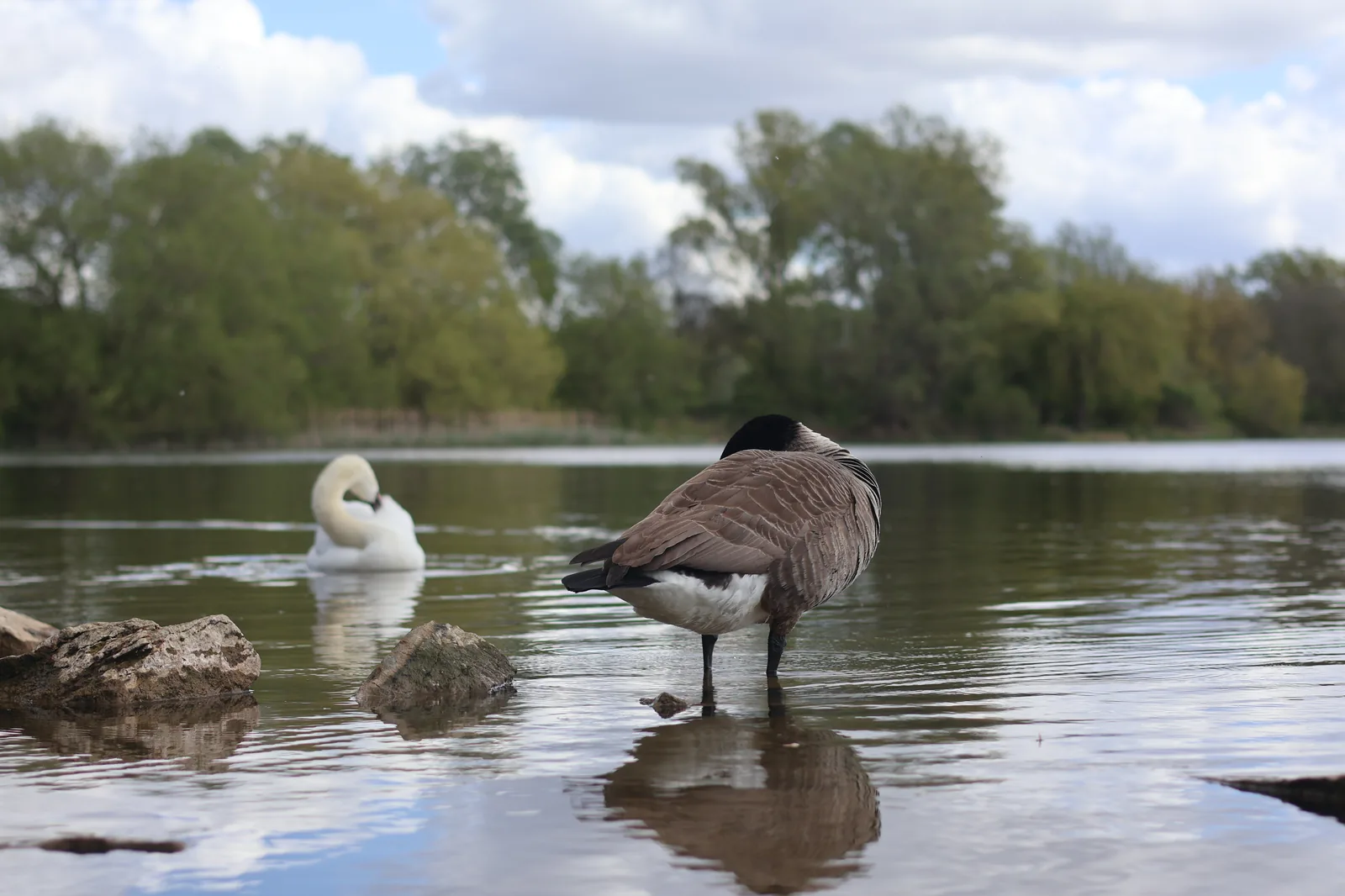
A real stretch of UK freshwater. Real birds, real water, real habitat — and behind it, the same fragmented monitoring picture that has held for decades.
A landscape built in pieces
Freshwater monitoring is fragmented for historical reasons, not bad ones. Different organisations grew up around different problems. Bird surveying at scale needed one set of tools and one community; invertebrate sampling needed another; fish data came from professional electrofishing surveys done every few years; water quality came from chemistry laboratories; cormorant predation evidence came from clipboards and shoeboxes; species records of rare flora came from naturalist networks; biodiversity assessments came from consultancies on retainer to developers.
Each of these communities has built something valuable. National biological recording networks are a treasure. Riverfly volunteers have created some of the best invertebrate baselines anywhere. Wetland bird counts have produced datasets going back decades. Water Framework Directive monitoring, for all its limitations, gives a chemical picture of rivers that few comparable systems match.
But none of these systems talk to each other. None of them share a coordinate space, a temporal scale, a data model. None of them gives a fishery manager, a rivers trust officer, or a regulatory caseworker a single view of what is happening on a piece of water. So when a regulator looks at a freshwater question — a licencing decision, an abstraction review, a habitat designation, a catchment plan — they assemble the picture themselves, from a dozen partial sources, slowly and inconsistently. The cost falls on the people who care most: small clubs, individual fisheries, rivers trusts, wildlife trusts, water companies trying to demonstrate stewardship to a regulator that wants more evidence than any single survey can provide.
What's missing isn't more data. It's a single place where data can live together.
What one platform should do
A complete monitoring stack for freshwaters has to cover a lot of ground at once.
It has to support biodiversity recording across every taxon that matters in a freshwater context — birds, mammals, fish, amphibians, reptiles, invertebrates, plants, trees, fungi. Not just the charismatic ones. Not just the rare ones. The everyday species whose presence and abundance is what biodiversity actually means. And it has to identify them automatically from photo or sound, because asking volunteers to be field naturalists in nine taxa is the wrong ask. The right ask is: take a photograph, and let the platform do the rest. AI verification at scale, with human review when the machine is uncertain, and a reference library the public can use without an account.
It has to monitor water quality alongside the species data, with an observation-led index built from what a volunteer can see and smell — not to replace laboratory chemistry, but to flag problems before laboratory chemistry would catch them.
It has to handle the predation question specifically. That means cormorants and goosanders, structured logging of sightings, roost counts, behaviour, and the non-lethal deterrents a fishery has tried. Without this, no fishery can build the evidence base for a control licence — and no regulator can make a defensible decision either way. And it has to produce regulator-grade evidence packs automatically: the Natural England A06 process has five published tests, and the platform should format submissions to those tests directly, so a fishery does not lose a year-long application cycle to a paperwork failure. Equivalent regulatory frameworks elsewhere need the same treatment.
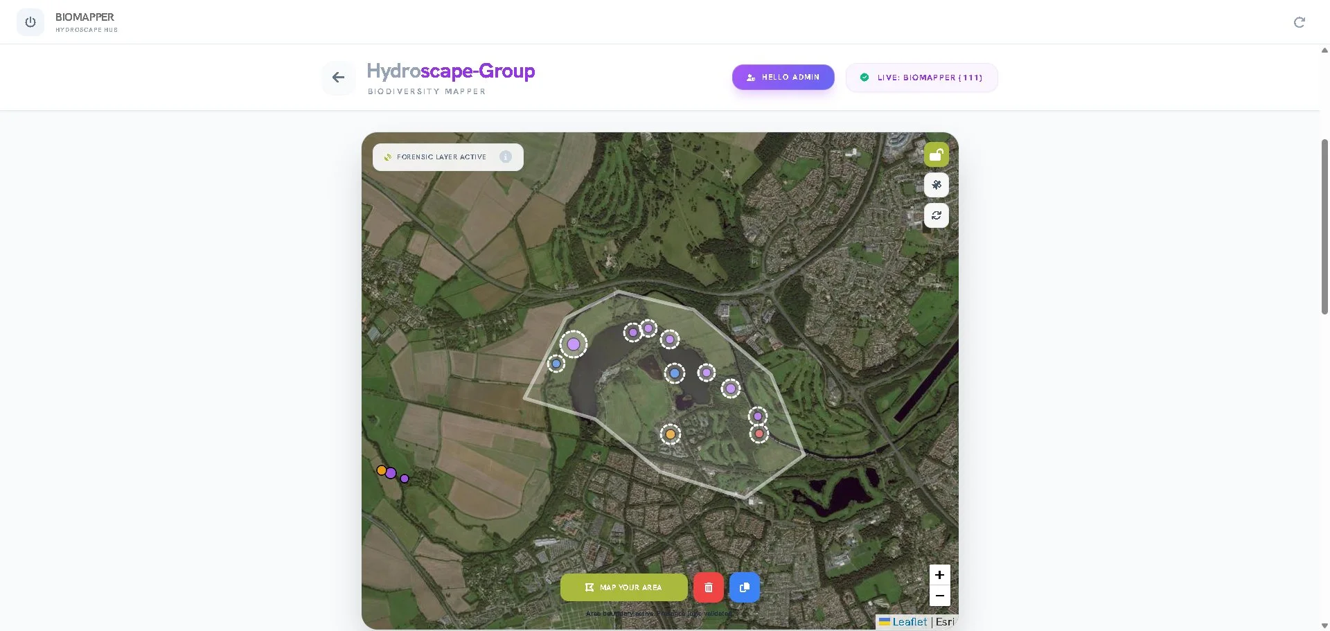
Draw a polygon around a stretch of water and the platform pulls every sighting inside it — birds, fish, invertebrates, deterrent logs, water quality readings — into a single integrated record.
It has to support biodiversity analysis at the level of the polygon. A trust officer, a fishery manager, a water company, or a regulator must be able to draw a zone on the map — a reserve, a beat, an operational site, a designated habitat — and immediately see species lists, abundance, diversity metrics, conservation concern ratios, and a four-page exportable report. Live, from the data already submitted. Not after a survey commission. And it has to scale to national level and beyond — a continuously-updating cluster map of every verified sighting, public-facing, free, contributing to the conversation about what is happening on freshwaters in real time, in any country where contributors are submitting.
It has to be frictionless: no app store install, no account required to submit, free at the point of use for volunteers and members and individual contributors. A platform that asks money from someone who wants to log a kingfisher is a platform that won't get the kingfisher record.
It has to be secure to a level the regulator and the data subject can both accept — UK-hosted, GDPR compliant, audit-logged, with an independent OWASP score that can be quoted in a procurement conversation without further work.
And it has to support the cormorant funnel end to end, free, including paperwork support, because the fisheries dealing with cormorant predation are the fisheries least able to absorb licencing application overhead. A platform that walks them through it is a platform that earns trust.
That's the list. Not aspirational. Not future-feature. The full requirement set for a complete monitoring stack on freshwaters as of 2026.
What makes a citizen sighting valid evidence
There is one objection a serious reader will have at this point, and it has nothing to do with the platform's feature list. It is the oldest objection in citizen science: can data submitted by untrained members of the public be trusted as evidence?
This objection has shaped policy for decades. It is the reason volunteer ecological data has historically sat at the margins of regulatory decision-making. It is also, properly answered, the reason a platform like Hydroscape has the chance to change the picture.
The honest version of the answer has three parts.
What a sighting actually contains
A submitted record on Hydroscape is not a written claim. It is a photograph or audio file, a GPS coordinate accurate to within a few metres, a timestamp from the device clock, and the audit trail of the submitting account. The contributor does not need to identify the species. The contributor does not need to estimate the count. The contributor does not need to know what they are looking at. They only need to capture what is in front of them.
What the platform does with it
The image or recording is processed server-side by an AI species identification model that returns a candidate species and a confidence score. Above a confidence threshold, the record is automatically classified. Below it, the record is flagged for human review. The original media is retained either way. The audit log records the AI's response, the threshold applied, and the eventual classification, so that any record can be re-checked by a regulator, a researcher, or a journalist working backwards from a published statistic.
What this means for validity
The platform produces verified data — checked, cross-referenced, traceable. Whether that data is valid for any specific regulatory question is a determination the regulator makes. But the precondition for any such determination is that the data exists in a verifiable form. That precondition is what the platform delivers, and the precondition is what no other platform delivers at this scale to volunteers using only the phone in their pocket.
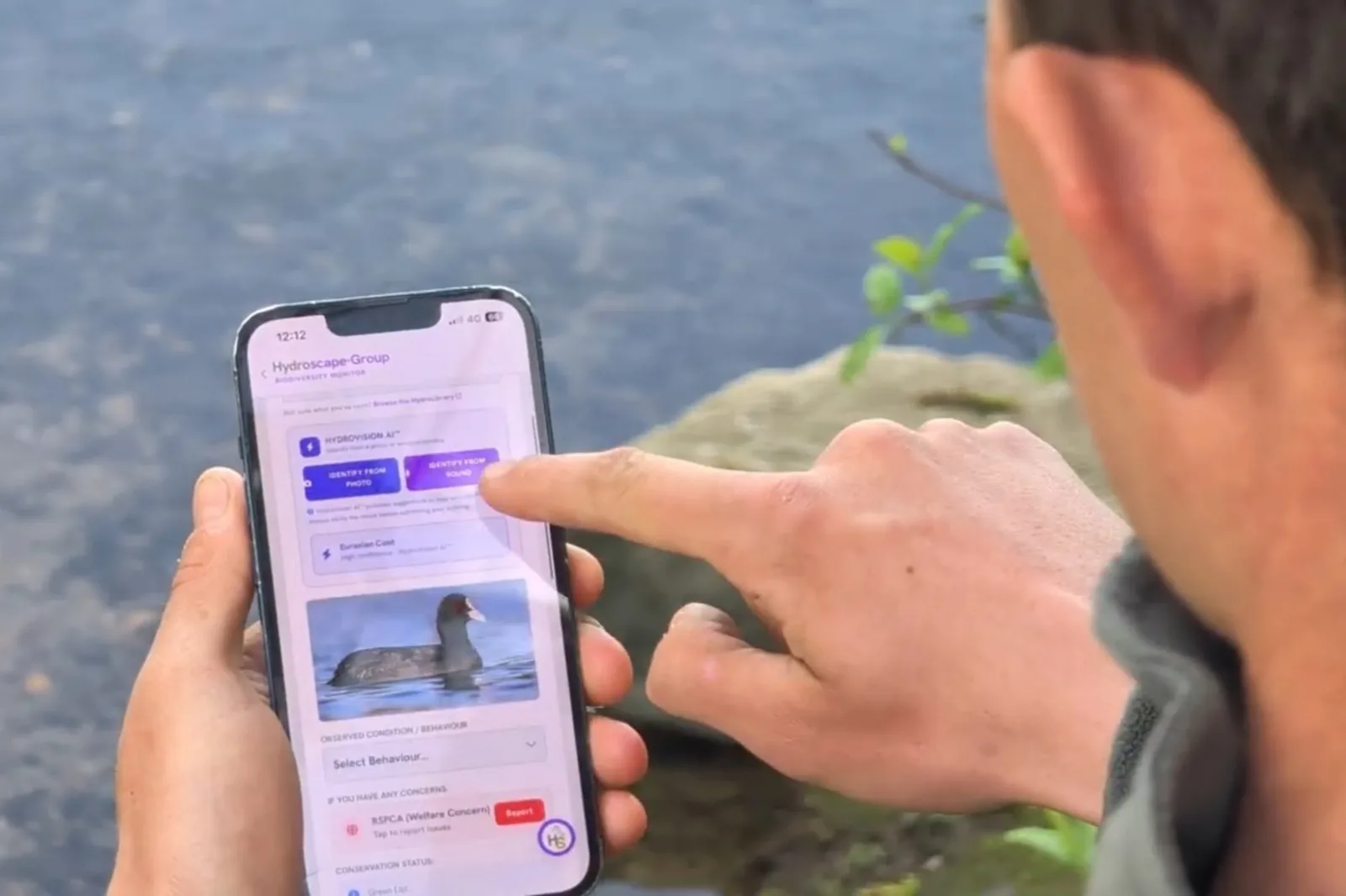
Photograph, AI-verified species identification, GPS, timestamp — the four components of a regulator-grade record, captured in seconds at the bankside.
The limiting factor on a contribution being scientifically useful is no longer the contributor's expertise, training, or professional credentials. It is the contributor's willingness to take a photograph. That is the shift that makes universal citizen monitoring viable.
Why no one has built it
The list is long because the problem is wide. Specialised platforms exist for many of these capabilities individually, and they are good at what they do. There are recording networks for birds, recording networks for invertebrates, AI identification platforms with global species coverage, regulatory dashboards for chemical water quality, BNG calculation tools for ecological consultants, GIS platforms for trust officers, paper-based application packs for predation licencing.
What does not exist — has never existed — is a platform that holds all of these capabilities in one product, against one integrated dataset, in real time, accessible to a volunteer with a phone and a regulator with a desk.
The first reason is structural. Each capability has been developed by an organisation whose mission addresses one part of the problem. A bird-recording charity is not in the business of running a predation licencing pipeline. A water-quality monitoring framework is not in the business of identifying cormorants from photographs. A species identification platform built for global naturalist communities is not in the business of producing evidence packs to a regulatory standard. None of them is wrong to specialise. But the specialisation is itself the gap.
The second reason is harder to say, and worth saying anyway. Some of the topics that need covering are politically easy. Biodiversity recording is easy: nobody objects to logging a kingfisher. Water quality is easy: nobody objects to flagging a pollution event. AI species identification is easy: it is novel, popular, and uncontroversial.
Other topics are not easy. Cormorant predation evidence is contested. Lethal management of protected species under licence is contested. Anglers as ecological observers is, for some quarters, contested. A platform that takes these on accepts a level of editorial and reputational exposure that a platform avoiding them does not. Most organisations, faced with that choice, choose the easier ground. The result is a landscape full of excellent specialised platforms that each cover the safe topics and a complete absence of platforms that cover the harder ones at the same standard.
Hydroscape was built specifically to fill that gap. Both gaps. The structural one — the integration. And the editorial one — the willingness to handle predation evidence, A06 applications, and the wider cormorant question alongside the biodiversity record, with the same data standards and the same regulatory rigour. We were not built to be uncontroversial. We were built to be useful, and the people on the bank do not have the luxury of waiting for someone else to take on the harder topics.
Facts are facts. The platform was designed to capture them, store them, and present them — and we want those facts in front of regulators, because better evidence should produce better decisions. The fishery making an A06 application deserves a regulator looking at six months of structured data, not a paperwork triage. The conservation body raising a concern about a designation deserves the same. The catchment partnership building a strategy deserves the same. The platform's job is to make sure the evidence exists, is verifiable, and is in the room when the decision is being made — and that the facts about a cormorant predation event are held to the same evidentiary standard as the facts about a great crested grebe nesting record.
That single integration — every taxon, every observation, every regulatory question, against one verified dataset — is the platform's defining property. The thing that makes Hydroscape different in kind, not just in degree, from anything else available.
On cormorants
Hydroscape exists in part because of cormorants. The platform's first specialised reporting form was the cormorant sighting form. The first regulator-grade evidence pack the platform builds is the A06 application. The first dedicated module within the platform is HydroDeter, for non-lethal deterrent logging. We do not pretend otherwise, and we do not apologise for it.
The cormorant question is contested. We are not neutral. But we are measured.
Cormorant predation on inland fisheries is real. It has been under-evidenced for decades, not because the evidence does not exist on the bank, but because no one has had a way to capture it. Fisheries dealing with serious predation pressure have, in many cases, lost stock for years and applied for licences with paperwork that does not match the strength of their case. That is the problem the cormorant funnel was built to fix.
Cormorants are also a protected species. Their presence on inland waters in increasing numbers since the 1990s is a regulated ecological reality, not a moral failing of the bird. Lethal control is permitted only under licence, only with proportionate non-lethal alternatives demonstrated, and only where the evidence supports it. We think this is the right framework. We think it is sometimes applied with insufficient evidence on either side of the application, which is a problem the platform also helps fix.
Our take on the cormorant situation:
- Predation is real and the evidence base for it has been thin. Verified, structured, auditable data fixes that.
- Non-lethal deterrents should be tried, properly logged, and their effectiveness tracked. The platform makes this easy.
- Lethal control under A06 licence is a regulatory tool, not a strategy. It is appropriate when the evidence supports it and the alternatives have been exhausted. It is not the answer to the cormorant question. The answer is a national record of what is actually happening, made by the people watching the water.
- Decisions made on common sense and verified data are better than decisions made on the loudest voice in the room — and that applies to anglers, conservationists, regulators, and consultancies in equal measure.
Common sense. Verified data. Responsible management. That is the cormorant situation as we see it.
The platform was built to support it, and the cormorant funnel is end-to-end free for fisheries because the fisheries that need this most are the ones least able to pay for the privilege of fighting their corner.
What the integrated platform enables
A cormorant sighting, a kingfisher record, a water quality reading, a non-lethal deterrent deployment, a roost count, a great crested grebe nesting record, a Himalayan balsam observation — all of these are submitted through the same platform, by the same kinds of contributors, into the same database, with the same coordinate system, the same time scale, the same audit log, the same verification stack.
This means the trust officer doing a quarterly biodiversity review on a polygon doesn't have to reconcile four datasets from four sources. They draw the polygon, the platform calculates Simpson, Shannon-Wiener, Pielou's Evenness, Margalef, Berger-Parker, Hill numbers, Menhinick, the Conservation Concern Ratio, and the species accumulation curve, and produces a report. From the same data feeding the public national map, the same data the angling club uses for its A06 application, the same data the catchment partnership uses for its strategy.
It means the fishery applying for a cormorant licence presents not just six months of cormorant counts, but six months of cormorant counts contextualised by the wider ecological record of the fishery — the fish stocking events, the kingfisher records, the otter sign, the water quality, the non-lethal deterrents tried. A regulator looking at that submission sees an applicant who understands their own water, not a paperwork exercise.
It means the rivers trust building a Biodiversity Net Gain baseline doesn't have to commission a one-off survey at one moment in time. They have continuous data, from a continuous community of contributors, building a continuous record. When a developer's consultancy submits a BNG calculation that disagrees with the trust's, the trust has the standing data to push back.
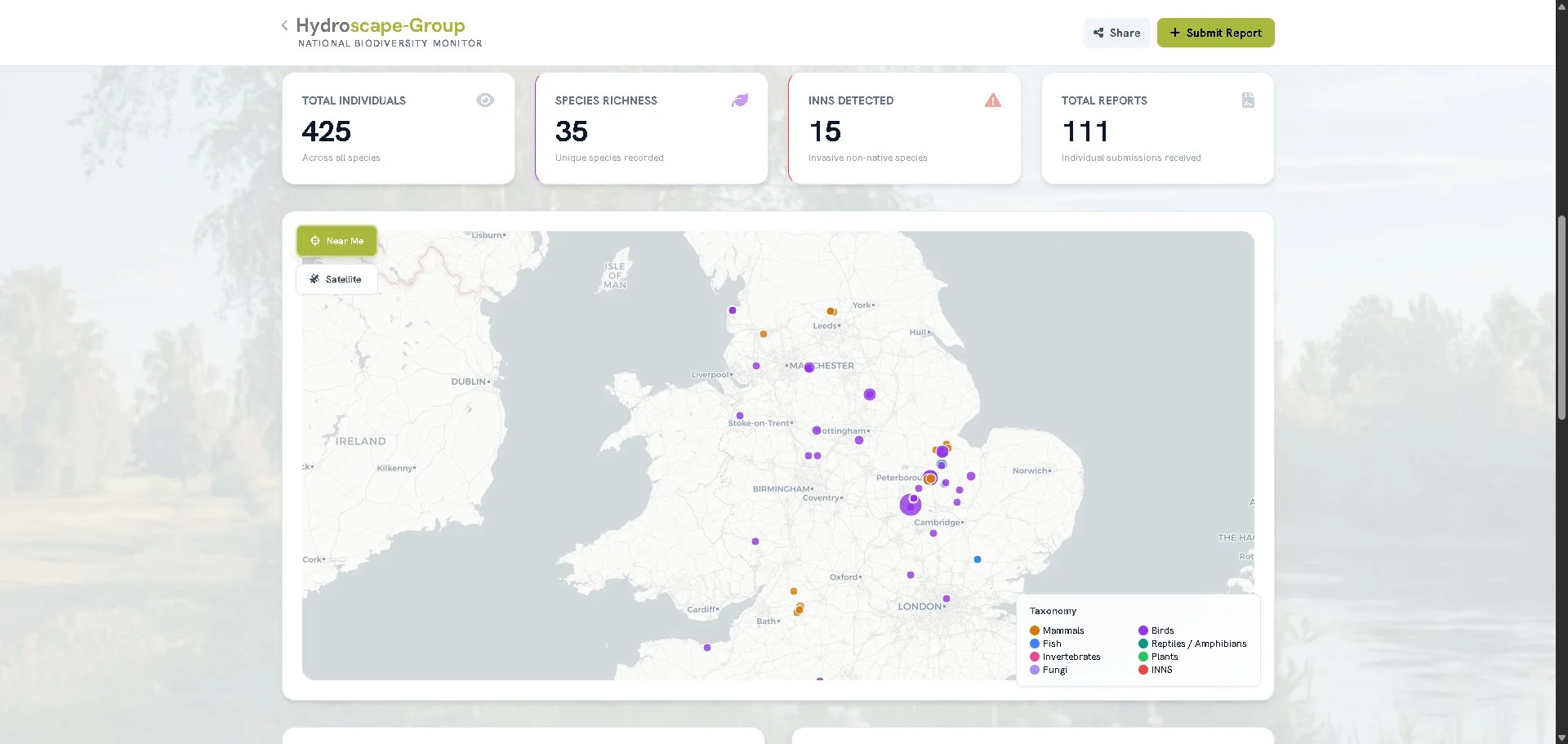
Every taxon, every contributor, every catchment — visible at a glance. The public-facing dashboard, updated continuously as records come in.
These are not separate stories. They are the same story, told seven different ways, by one platform, built by every average person who decided to take the photograph.
Where we are
The platform is live. It supports five reporting forms covering cormorants, biodiversity, water quality, roost surveys, and non-lethal deterrents. The HydroLibrary holds reference cards for over 1,000 species, in 22 languages. AI verification covers photo and audio submissions. The biodiversity audit tool calculates nine metrics live from the data. The A06 Master Builder formats evidence packs to Natural England's published tests. The water quality index draws on nine factors. The public dashboard shows the national picture, updated continuously.
Over ten thousand verified sightings have been logged. Several dozen UK angling clubs and fisheries are using the platform. Initial meetings have been held with Natural England and the Environment Agency. The platform was featured in Angling Times in March 2026. The Hydroscape App is live on Google Play. Independent OWASP audit: 10 out of 10. UK-hosted. GDPR compliant.
Hydroscape is built by passionate fishery managers with decades of hands-on experience in water management, biodiversity, habitat improvement, and freshwater ecology. We built the platform we wished had existed twenty years ago.
The platform is built in the UK and currently used predominantly by UK organisations, but the integration argument and the verification stack apply to any freshwater in any country. The species library is UK-weighted, supports 22 languages, and works globally. We are open to research collaborations and pilot deployments anywhere the case for an integrated platform is being made.
The cormorant funnel is free, end to end
From sighting submission, to non-lethal deterrent logging, to A06 evidence pack generation, to direct paperwork support for the application itself — the cormorant funnel is end-to-end free for fisheries. We do not charge clubs or fisheries for cormorant licencing support. We do not put it behind a tier. We do not gate the evidence tooling behind a paywall.
The whole pipeline is free, because the fisheries dealing with cormorant predation are the fisheries that cannot absorb the cost of fighting for the evidence to defend their stock.
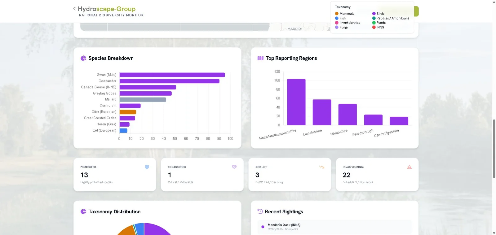
A working national record: which species, where, and at what conservation status. Live, today.
What we'd ask of you
If you have a stretch of freshwater you care about — as an angler, a fishery manager, a trust officer, a water company employee, a regulator, a researcher, a volunteer — see what the platform does on your geography, your species, your data.
The platform is at hydroscape-group.co.uk. The reporting forms are free and need no account. A free MyHydroscape account gives you a personal dashboard, a record of your contributions, achievement badges, and exportable reports. Organisations interested in dashboard access, polygon biodiversity audits, A06 support, or research collaboration can email info@hydroscape-group.co.uk for a 30-minute platform demonstration tailored to their work.
The platform is being built every day. It is the closest anyone has come to a complete monitoring stack for freshwaters. It exists because thousands of people have decided to start writing things down — and because the platform was designed so that taking a photograph is enough.
Join them.
See the integrated platform on your geography
Book a 30-minute platform demonstration. We'll walk through your region, your species, and your data — and show you what end-to-end freshwater monitoring enables for the work you're already doing.
Book a Demo